Browsing Category Transportation

Charlottesville is the 3rd Most Walkable City in Virginia

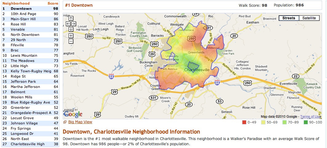
50% of Charlottesville residents have a Walk Score of 70 or above.

Charlottesville’s most walkable neighborhoods are Downtown, 10th And Page, Main-Starr Hill. Charlottesville’s least walkable neighborhoods are Charlottesville High, North East, Longwood Dr. 77% have a Walk Score of at least 50—and 23% live in Car-Dependent neighborhoods.

Downtown, Charlottesville - Restaurants, Hotels, and Landmarks on Walk Score.jpg Search for the most walkable homes for sale in Charlottesville .

Read More

Northtown Bike Trail – From Downtown to 29 North – Looks Great

The Northtown Trail is a smart, functional, bold and audacious plan that would likely help shape non-auto-dependent growth, reduce congestion on 29 and maybe help folks using it get more fit .

…The Northtown Trail is tied to several significant roadway projects in the area, including the Route 250 Interchange at McIntire Road , McIntire Road Extended , the Meadow Creek Parkway and Berkmar Drive Extended . The portions of the trail in Albemarle County correspond directly to planned facilities for the Places29 Master Plan, which aims to improve congestion and land use issues along the US 29 north corridor in Albemarle County. … The City’s portion of the conceptual trail corresponds to planned bike and pedestrian facilities along the future McIntire Road Extended and the Route 250 interchange at McIntire Road.

Read More

Shutting Down a Successful Train?

There has to be a way … shame the success is in the hands of politicians. Beginning service Oct. 1, 2009, in its first year the train brought in close to $6.4 million in revenues, far exceeding the $2.58 million that officials expected it to garner. Courtney Ware, a spokeswoman for the Virginia Department of Rail and Public Transportation, said Amtrak estimated that the train’s annual operating costs would be roughly $5.48 million. “The train is making a profit,” Richards said.

Read More

The Meadowcreek Parkway Might Be Completed

Councilors voted 3-2 — with Mayor Dave Norris and Councilor Holly Edwards opposed — to allowActing City Manager Maurice Jones to endorse the project’s draft memorandum of agreement, which lists the measures the city will take to lessen the negative consequences of building the two-lane road through one of Charlottesville’s largest parks. The proposed measures outlined in the memorandum are to establish two rain gardens that exclusively use native plants; have a landscape plan to integrate the city’s portion of the parkway into the setting’s existing natural features and minimize its influence on McIntire Park; install signage prohibiting truck traffic and posting a speed limit of 35 mph; complete photographic documentation of the eastern side of the park; and complete historical documentation of the McIntire Golf Course.

…I still wonder – if we were designing a transportation solution today rather than trying to implement a 40-year-plus plan , would we create the Meadowcreek Parkway?

… The relationship between the City of Charlottesville and the County of Albemarle is akin to that of divorced parents who really kind of hate each other but are able to keep it together justenough to keep the kids fed.

Read More

Bicycle Safety Discussion Next Week

To continue the momentum created by the Citizen’s Bike Safety Committee established by the City this year, the City of Charlottesville, in partnership with Bike Charlottesville, will hold a community discussion on Wednesday, October 20th beginning at 7pm at CitySpace in the Market Street Parking Garage downtown.

I’d also like to see discussions about bike helmets, like this one at the WSJ .

Wouldn’t it be nice if the County of Albemarle and the University of Virginia participated in the conversation as well? I do particularly like this helmet , though. yakkay -helmet.jpg

Read More

Transportation Costs and Housing Affordability

If Walkscore put walkability on the real estate map (it’s getting better all the time, by the way), the new online tool Abogo might do the same for transportation affordability. … Seeing this number in black and white may help diffuse the old drive-til-you-qualify myth – that you can find more house for the money the further from the city you move. Living in lower densities may pose less up-front costs per square foot, but the ongoing cost of getting to where you need to go on a regular basis is real and likely much higher. … The numbers look high to me , and my transportation numbers are going to be higher than the average user (I do drive pretty much for a living).

Read More