Several years ago in Crozet, before the Old Trail neighborhood was as populated as it is (and is yet to be), before Haden Place neighborhood had broken ground … before the new Crozet Library was finished, Jarmans…
Posts tagged walkability
Paying More for Walkable Homes in Charlottesville?
That’s the theory put forth by the Piedmont Environmental Council and reported on at Bacon’s Rebellion.
The conclusions apparently found in their study of 120 homes aren’t a surprise to readers of RealCentralVA (see links at the end of this post), but I wanted to differ with one of the conclusions with three points:
Many people continue to prefer living in the suburbs. But Werner’s divergent trend lines make it clear that supply-side of “walkable urbanism” housing is severely under-served.
— With a reference to a story I wrote in January (and will be revisiting soon)
Apartments – there are going to be a lot more available in 2013 and 2014. A few of the new complexes: Arden Place (Rio Road), The Pavilion at North Grounds (Millmont/UVA), Stonefield Commons (Hydraulic & 29), The Reserve at Belvedere (Rio), the Plaza on West Main (UVA), City Walk (Downtown – more on the Coal Tower). As I said, a lot more apartments will be coming on the market soon.
— And also point out that there are quite a few new construction neighborhoods in the City of Charlottesville that offer true walkability for those wiling to live that urban lifestyle (and can afford to do so).
— And that buying a car just isn’t a desired option for a lot of millennials; many of them want the urban lifestyle (and often that means renting rather than buying):
Economic realities: The costs of owning a car just keep increasing. A 2012 AAA study found the expense of having a car totaled $8,946 annually on average, nearly 2 percent more than the previous year. As transportation alternatives increase, the desire to own your own car diminishes. You’ve got I-Gocar sharing and Zipcar. I love Zipcar’s slogan — it says it all for this generation: “The car for people who don’t want one.” There are also shared ride programs, company-provided transportation plans and the old reliables: biking and walking. The Gen Y stats (16- to 34-year-olds) are pretty impressive: Driving was down from 2001 to 2009 (23 percent), biking was up (24 percent) and walking was up (16 percent), according to the National Household Travel Survey.
Related reading:
– Where Are the Walkable Neighborhoods in Charlottesville/Albemarle? (2008)
– Charlottesville is the 3rd Most Walkable City in Virginia (2010)
– Choosing Where you Want to Live in Charlottesville – Walkability and Safety Top the List (2013)
– Walkability=Affordability= Profitability=Livability (2009)
Walking – Biking – Driving Directions all-in-one
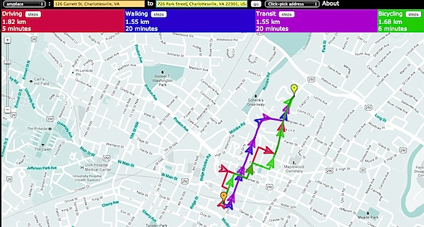
Brilliant. Want to know which is faster – walking, biking, driving? That’s easy enough to discern using Google Maps, but in a quest for efficiency, Michael Schade at the Mobility Lab has constructed the Side-by-Side Router:
Once you pick two end-points, the four modes’ routes are drawn with different colors. It’s been surprising to see how the routes vary depending on the mode. The program also gives you the total travel time and distance for each mode.
For example: there’s a house on the market on Park Street; it’s Walk Score is 68. To get from my office to that house, I’d say that bicycling is a better choice than driving. (click to see full size) Simple. Colorful. Brilliant.
This is a fantastic research tool for homebuyers, sellers and folks moving to the Charlottesville area … keep in mind that the directions are likely mostly right as are the business listings … things change, and the best way to know if a route if truly walkable or bikeable is to walk or bike the routes you’d be doing.
(it’d be supercool if I could embed this map. 🙂 )
Walkable Neighborhoods Have Happier Residents
Yeah, the info graphic below is for/from California, but the data points are universal.
And, because images aren’t searchable, the three points:
– Lose Weight! The average resident of a walkable neighborhood weighs 6 to 10 pounds less than someone who lives in a car-dependent neighborhood .
– Save Money! Transportation is the second largest expense for American households, costing more than food, clothing, and health care.
– Connect! Studies show that for every 10 minutes a person spends in a daily car commute, time spent in community activities falls by 10%
Cville Bike mApp – Track your Bicycle Rides for the Next Month
People want to be close to stuff, and they want to be able to get to that stuff easily. More often, in the City of Charlottesville and more urban parts of Albemarle, “getting to that stuff” includes bicycles. Now the Charlottesville MPO is seeking to capture data that will show how many are biking to places.
Walkability matters ; so does bikeability.

For the next month or so I’m going to be using the Cville Bike mApp to track my bicycle rides around Charlottesville and Crozet instead of MapmyRide.
On April 14th the Charlottesville-Albemarle Metropolitan Planning Organization (MPO) will release the Cville Bike mApp, a free, bike route mapping application for iPhone and Android phones. The App allows cyclists to record their trips and send the trip information to the MPO for transportation planning purposes. With an expected decrease in federal transportation funding, this data will help elected officials better determine where to target limited available funds for future cycling enhancements and improvements. This data input effort will also position the region to be more competitive for transportation grant funding. More specifically, the App will allow transportation planners to map cycling patterns, determine cycling corridors, identify cycling barriers and find appropriate locations for cycling facilities.
The MPO will be collecting cycling data over an approximately one month period – from April 14th to May 18th. Help local planners and elected officials improve cycling in Charlottesville and Albemarle by recording your bike trips using the Cville Bike mApp. Remember, mApp it for Better Biking!
I have no doubt that I could find significant and substantial data to support the opposite perspective, but in my practice, I have found that my clients value bicycle and walking paths and accessibility. Can I place a quantitative value on that? No; sometimes it’s a matter of “will they buy it?” Yes or No.
The League of American Bicyclists noted in 2010:
As we pointed out in our report, The Economic Benefits of Bicycle Infrastructure Investments, studies have shown that real estate property values increase with proximity to bicycle paths. People enjoy living close to bike paths and are willing to pay more for an otherwise comparable house to be closer to one.
What is Walking Distance to You? (in Charlottesville)
“Walkable houses in Charlottesville” – one of the more frequent requests I get both from buyer clients and from visitors to this site.
But “walkable” means different things to different people.
Clarifying and pulling out buyers’ true intents is one of the most useful skills a good real estate agent brings to the table. For example, when a new buyer client tells me that he wants to be within “walking distance” of the Downtown Mall, I always follow up with:
“What is walking distance to you?”
Your response of “less than 30 minute walking distance” is why I asked … my non-American-based clients have a much more liberal definition of close (usually less than 30 minutes or 2 miles) than do my American clients (less than 10 minutes or 5 blocks).
So the question is – what does walkable mean to you?
As I do with a lot of the stories that make it to this here real estate blog, I started by asking on the social networks – Twitter, Facebook and Google+
The City of Charlottesville has a lot of highly “walkable” homes, using Walkscore as the guide, and there are an awful lot of condos in the City of Charlottesville that offer walkability.
Meadowcreek Parkway Opening (for bicyclists and pedestrians)
From Charlottesville Tomorrow:
In other news, Huja announced that VDOT has agreed to open up the county’s portion of the parkway to cyclists and pedestrians by the end of July. Another agreement between the city, county and VDOT prevents the road from opening to vehicular traffic until the interchange and both road sections are all completed.


